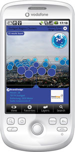
 Stuttgart Region Clusters visualizes various industry clusters in the Stuttgart Region, South Germany, in Augmented Reality. The idea was to put location information back into it’s location context. We visualized former tabular raw data in Augmented Reality using simple dot clouds. More or less dense clouds represent the number of companies of a specific industry in that specific region or district.
Using Stuttgart Region Clusters on a Layar equipped mobile phone provides a totally new user experience on industry cluster representation, best done from an exposed view point. Therefore I went up the Stuttgart TV tower to show the power of AR industry cluster visualization from 150 meters above the city’s rooftops. By the way: the Stuttgart TV tower was the world’s first TV tower, it was built in 1954 and it’s 217 meters high.
I was one of the first 50 developers worldwide granted access to the upcoming Layar open platform during the Layar Beta Developer Program in summer 2009. I created Stuttgart Region Clusters as one of the first applications built on top of this new open platform. This work was presented at Layar NEXT event in August 2009 when Layar launched its open platform Layar 2.0.
Stuttgart Region Clusters was designed and created in cooperation with the Stuttgart Region Economic Development Corporation. It’s mostly used for marketing purpose.
Gallery
Visit the Hoppala Stuttgart Region Clusters gallery on Flickr.


