-
Press
 Rebuilding the Berlin Wall with Augmented Reality
Du willst die Berliner Mauer sehen? Bitte sehr! Categories
-
Recent Posts
Archives
Author Archives: Marc
Layar meets Qype
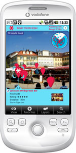
 Turn your mobile phone’s camera display into a local information and recommendation portal with Qype for Layar. Just point your handset to any restaurant or bar around you and learn about people’s recommendations. “Layar meets Qype” brings Qype recommendations of restaurants, bars and events right onto your mobile phone. Qype.com is the leading recommendation portal in Germany, Great Britain and France.
Imagine being in a yet unknown city, looking for a good restaurant in the area. Just use the camera of your mobile phone to view the area around you and immediately find local recommendations of the Qype community magically merged into your camera view. Information widgets show fotos of the place, community ratings, the distance and direction. You can easily browse through the community recommendations on your handset with just one click. Read more…
Posted in Projects
Leave a comment
Stuttgart Region Clusters
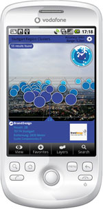
 Stuttgart Region Clusters visualizes various industry clusters in the Stuttgart Region, South Germany, in Augmented Reality. The idea was to put location information back into it’s location context. We visualized former tabular raw data in Augmented Reality using simple dot clouds. More or less dense clouds represent the number of companies of a specific industry in that specific region or district.
Using Stuttgart Region Clusters on a Layar equipped mobile phone provides a totally new user experience on industry cluster representation, best done from an exposed view point. Therefore I went up the Stuttgart TV tower to show the power of AR industry cluster visualization from 150 meters above the city’s rooftops. By the way: the Stuttgart TV tower was the world’s first TV tower, it was built in 1954 and it’s 217 meters high. Read more…
Posted in Projects, Videos
Leave a comment


